

Second World War: bomb damage
1. About this guide
This is a guide to the records available at The London Archives for identifying areas of London that were subject to bomb damage during the Second World War.
The main sources are:
- bomb damage maps which show the scale of damage in different areas
- fire brigade and civil defence reports which give you some information on the actual incident and when exactly it took place
2. Bomb damage maps
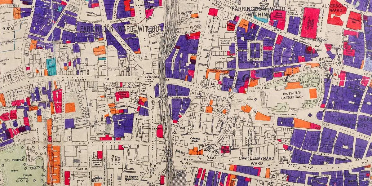
2.1 County of London
The bomb damage maps for the County of London were created by the Architect's Department of the London County Council (LCC) to record cumulative damage to buildings within the Council's area.
The full set of 110 maps are colour coded to show the levels of damage:
- Green: Clearance area
- Yellow: Blast damage, minor in nature
- Orange: General blast damage, not structural
- Red: Seriously damaged, repairable at cost
- Dark Red: Seriously damaged, doubtful if repairable
- Purple: Damaged beyond repair
- Black: Total destruction
The locations where long rage rockets landed are marked by large circles for V1 rockets and small circles for V2 rockets.
The maps can be viewed on the London Picture Archive at LPA 346095. They are also published in a book entitled the 'London County Council Bomb damage maps 1939-1945' by Laurence Ward' which is available in our library on shelfmark 67.87 WAR. This book contains not only the maps, but also details of how the architect’s department functioned throughout the war and how they went about recording the damage.
2.2 City of London
Although the City of London is covered by the LCC maps described in Section 2.1., there is also a separate series of maps just concentrated on the square mile itself in COL/PL/01/165/B/001-055.
These maps use the following colour and classification scheme:
- Green: Open spaces including disused burial grounds
- Red: Buildings demolished
- Grey: Buildings seriously damaged with the shell of one or more floors still standing
- Pink: Buildings that were previously in the above category, but which are now reinstated in whole or in part
- Brown: Sites vacant not by reason of enemy action
Unfortunately, the original maps are in a poor condition so can't be accessed in person. Copies of the maps are however published in 'London County Council bomb damage maps 1939-1945' by Laurence Ward which is available in our library on shelfmark 67.87 WAR.
2.3 County of Middlesex
There is a series of bomb damage maps for the County of Middlesex in MCC/ES/PL/01/001-007. These were created by the Middlesex County Council.
In order to look at these you will need to identify the correct sheet number from the key to the 25 inch Ordnance Survey maps for Middlesex. This key can be found in the map cabinets in our public rooms and also on the National Library of Scotland's website by selecting 'view graphic index' on the Ordnance Survey: 25 inch maps for Middlesex webpage.
Once you know the sheet number, you can then order the correct map folder. For example, Wembley Stadium is on Sheet Middlesex XI.13 and can therefore be found in MCC/ES/PL/01/003.
Damage is recorded in three categories:
- Category A which is a dark red for the most damage
- Category B which is orange for mid-level damage
- Category C which is yellow for the least damaged
3. Fire Brigade and Civil Defence reports
3.1 London County Council Fire Brigade air raid fire reports
The London County Council (LCC) Fire Brigade air raid fire reports are a series of original reports on incidents due to enemy action. They are comprised of 65 volumes in LCC/FB/WAR/02/001-065 and cover 13 May 1940 to 28 March 1945.
Up until 18 August 1941, the volumes only cover the County of London (what we think of today as the Inner London Boroughs). After the LCC Fire Brigade becomes part of the National Fire Service, the reports cover a larger area roughly equivalent to that within the boundary of the current M25 motorway.
The volumes are arranged geographically rather than being in strict chronological order. They record the date and time of the incident, the location, the name of the resident or business/organisation if known and the type of premises affected. A small description is given about the level of damage that has been sustained. The cause of the incident i.e. the type of bomb/rocket is noted. The number of casualties is also recorded, although only Fire Brigade staff are usually named. Other information provided includes details of who or where the call came in from, the name of the officer in charge at the scene and details of the number of pumps or other appliances that attended.
In order to find an entry, you really need to have a rough idea of the exact date. The team are however undertaking a project to index the reports so that they are eventually searchable by personal name, street and business. The entries up to 5 July 1944 can now be searched in the Mediatheque in our public rooms.
3.2 Middlesex County Council Civil Defence air raid log books
From 18 August 1941, the County of Middlesex is covered by the LCC Fire Brigade air raid fire reports as described in Section 3.1.
Middlesex County Council (MCC) did however have their own set of air raid log books in MCC/CD/WAR/01/001-037 giving the following information: date, message time, incident time, and particulars including location, damage and types of devices used as well as remarks sometimes including the number of casualties.
Log books exist for the whole county and are split into the following areas: Acton, Brentford and Chiswick, Ealing, Edmonton, Feltham, Finchley, Friern Barnet, Harrow, Hayes, Hendon, Heston & Isleworth, Hornsey, Potters Bar, Ruislip-Northwood, Southall, Southgate, Staines, Sunbury, Tottenham, Twickenham, Uxbridge, Wembley, Willesden, Wood Green, Yiewsley-West Drayton, Barnet, East Barnet, Bushey, Cheshunt, Elstree.
3.3 London Civil Defence Region situation reports
The situation reports of the London Civil Defence Region give an overview of the previous 12-hour period. They are particularly useful for mentioning hits to public infrastructure, services and utilities such as docks and canals, railways, hospitals, important factories, important roads and tunnels, telecommunications, public utilities and electricity supply.
Although less detailed than the LCC air raid fire reports (see Section 3.1), they often include events that have not been mentioned in this series.
The London Civil Defence Region covered an area roughly equivalent to today's Greater London. Three duplicate series have survived with slightly different covering dates:
- Daily (later twice-daily) situation reports, 25 August 1940 - 28 March 1945 in LCC/CL/CD/02/001-010
- Situation reports, 18 September 1940 - March 1945 in LCC/CE/WAR/04/003-011
- Twice daily situation reports, September 1940 - April 1943 in LCC/FB/WAR/LFR/017-032